Yen Minh trekking guide: southern valleys, forests and Du Gia walks
Yen Minh trekking guide — southern valley forests, Du Gia walking and how this district differs from Hoang Su Phi terraces and Dong Van karst.

Yen Minh trekking guide: southern valleys, forests and Du Gia walks.
This guide focuses specifically on yen minh trekking — the southern district for valley and forest walking on published Village Treks programmes — not a loop-road photo stop, not province-wide planning and not day-by-day Du Gia field notes alone.
yen minh hiking on this site means working farm paths, river corridors and multi-ethnic hamlets reached on foot — principally the Du Gia forest villages day walk and slower multi-day valley stays when tour pages list them — not inventing unnamed trails or viewpoints outside published products.
This page owns the district — landscape, forests and valleys, village experiences, difficulty, seasons, route ideas and how Yen Minh fits longer itineraries — not village collection depth (Village trekking in Ha Giang), not Du Gia valley field depth (Hidden Valleys of Ha Giang; Du Gia practical guide) and not Quan Ba’s Nam Dam crossing owner (Quan Ba trekking guide).
We describe only verified programme, hub and logistics copy on this site. Yen Minh is a real district on the road south-east from Ha Giang city — a trekking region with published valley walks, not a slogan about empty trails.
- The complete guide to trekking Ha Giang
Province overview before district choice.
- Village trekking in Ha Giang
Village Treks collection depth — parent topic.
- Hidden Valleys of Ha Giang
Du Gia valley research — not this district owner.
- Hoang Su Phi vs Dong Van trekking
West terraces vs northern plateau compare.
- How to plan a Ha Giang trek
Planning sequence after district fit.
- Village treks hub
Compare routes, difficulty and seasons at this collection hub.
- Du Gia forest villages
Easy day walk in Du Gia · Yen Minh.
Why trek in Yen Minh?
Yen Minh matters for trekkers because it holds the southern valley approach to Du Gia — lower, warmer walking between 700 and 1,050 m with Tay, Hmong and Dao hamlets on farm paths, not high terrace amphitheatres or plateau karst rim days.
Loop travellers often pass Yen Minh town by road toward Dong Van. On this site, trekking yen minh district means leaving the vehicle for published walking days in the Du Gia valley and related Village Treks logistics via Yen Minh.
Choose Yen Minh when village contact, forest shade and an Easy day return matter more than harvest-gold photography or Demanding ridge shelter nights.
- Ha Giang trekking for beginners
Easy first-trek shortlist including Du Gia.
- Family trekking in Ha Giang
Family fit on Easy valley days.
Landscape of Yen Minh trekking.
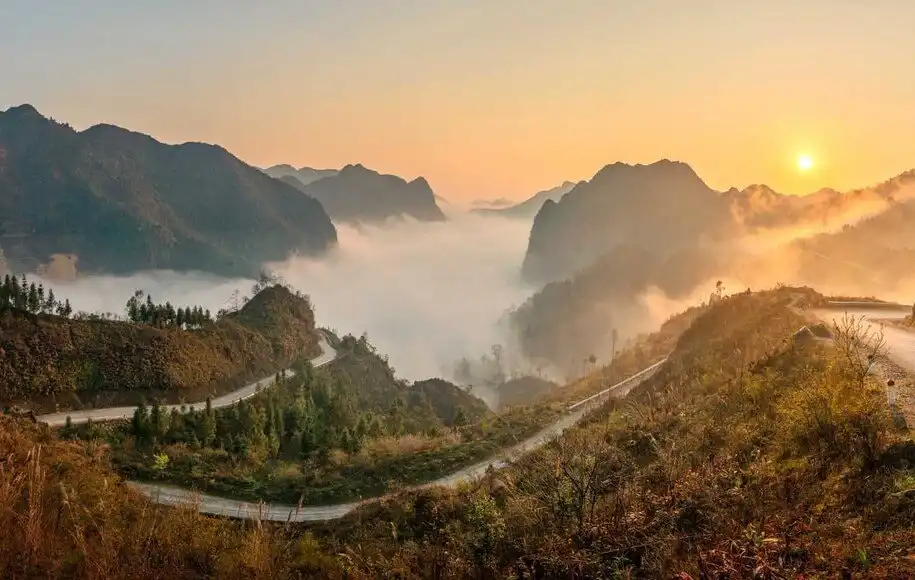
Published Du Gia copy describes a forested southern valley with rivers, bamboo, waterfalls and terraced fields between 700 and 1,050 m — green working ground rather than open limestone plateau.
yen minh walking trails on programmes follow village paths, irrigation channels, wooden footbridges and soft forest contours — not a marked national-park trail network with numbered stages.
Compared with Hoang Su Phi, the scale is valley and hamlet, not steep La Chi terrace walls above the Chay. Compared with Dong Van, the rock is less dominant and evenings are milder than northern plateau homestays.
- Hoang Su Phi vs Dong Van trekking
How west and north differ from southern valleys.
- Rice terrace trekking in Ha Giang
When terrace amphitheatres are the priority instead.
- Hoang Su Phi programmes
Compare routes, difficulty and seasons at this collection hub.
Forests and valleys.
Du Gia’s published day circuit moves through bamboo forest paths, river crossings into Hmong farmland and a forest descent past the lower waterfall pool when water levels allow — guide field notes skip the pool when the river runs brown after rain.
Valley pace is the point: lunch lasts because a host kitchen is cooking, not because a schedule requires a viewpoint stop. Trail mud can persist 24–48 hours after rain on these lower paths.
Mountain trekking on the upper Tay Con Linh massif is a different product line entirely — Demanding Ridge & Cloud programmes are not Yen Minh district walking.
- Mountain trekking in Ha Giang
Ridge massif — different from Yen Minh valleys.
- Remote village trekking in Ha Giang
Quieter village product choice on Village Treks.
- Du Gia forest villages
Forest and river circuit — Easy.
Village experiences.
The published Du Gia day visits three working hamlets on foot — Du Gia’s Tay centre, a Hmong hamlet upstream and a Dao community on the forest ridge for lunch — all on farm paths.
Hosted lunch in a stilt house is part of the programme Includes. Overnight homestays in Du Gia can be arranged separately when you enquire; the day walk itself returns to the village without a programme homestay night.
Nam Dam to Lung Tam is labelled Quan Ba · Yen Minh on the Village Treks hub — district ownership for that three-day crossing stays with the Quan Ba trekking guide; Yen Minh here is the broader southern corridor context, not a second Nam Dam owner.
- Du Gia practical guide
Fitness, packing and booking for the valley walk.
- Quan Ba trekking guide
Nam Dam crossing district owner.
- Ethnic minority trekking in Ha Giang
Cultural route choice across collections.
- Homestay trekking in Ha Giang
When overnight hosting is the goal.
Trekking difficulty.
Du Gia forest villages is Easy on the hub — 11–13 km, roughly 5–6 hours walking, no ridge exposure above 1,050 m. It is the gentlest published Village Treks entry and a common first booking.
Longer southern-valley pacing on the four-day Du Gia slow trek (Hidden Valleys Slow Trek on /tours) keeps walking days unhurried — confirm difficulty and day blocks on the tour page.
Do not treat Yen Minh as uniformly Easy if your calendar adds Nam Dam or northern plateau days — those carry Moderate labels and different overnight norms. Fitness and difficulty owns tier definitions.
- Ha Giang trekking fitness and difficulty
Easy, Moderate and Demanding labels.
- Ha Giang trekking for beginners
First-trek Easy shortlist.
Best seasons for Yen Minh.
Du Gia walks year-round on published notes, with best overall comfort often cited September through April. Lower altitude keeps evenings milder than Lo Lo or ridge shelter nights.
Green-season rain still matters — muddy paths and brown river levels change the waterfall option. Dry shoulder months favour clearer forest walking without cold-plateau kit stacks.
Best time for Ha Giang trekking owns the province calendar. Match Yen Minh valley days to that guide when combining with harvest terraces or plateau buckwheat elsewhere.
- Best time for Ha Giang trekking
Master season calendar.
- Green season trekking in Ha Giang
May–August pace when summer dates are fixed.
Suggested route ideas.
These are planning concepts from published products — not invented yen minh walking trails. Confirm schedule and Includes on each page.
Concept A — Classic yen minh trekking day: Du Gia forest villages as a same-day return with hosted lunch, after a valley or Ha Giang city night.
Concept B — Slow valley stay: Hidden Valleys Slow Trek for four days based in Du Gia with gentle river and forest walking and consecutive nights in the same Tay homestay as listed on the tour page.
Concept C — Southern then plateau: Du Gia Easy day, then continue by road toward Quan Ba or Dong Van for Moderate overnight or extended journey days — logistics spine first.
- Du Gia forest villages
- Hidden Valleys Slow Trek
Four-day Du Gia valley journey.
- Ha Giang trekking itineraries
Duration compare across collections.
- Trekking logistics in Ha Giang
Arrival and transfer order.
How Yen Minh fits longer trekking itineraries.
Most guests reach Du Gia from Ha Giang city via Yen Minh in three to four hours by road. A city or valley night before walking day keeps Day 1 for hamlets and forest rather than the transfer.
Yen Minh often opens a multi-region calendar: Easy southern valley contact first, then Hoang Su Phi terraces west, or Quan Ba / Dong Van days further onto the plateau — sequence depends on season and fitness.
Getting to Ha Giang for Trekkers covers the Hanoi–Ha Giang road buffer. Do not plan same-day Hanoi to Du Gia walking unless you accept exhaustion.
- Getting to Ha Giang for Trekkers
Road buffer before Yen Minh / Du Gia days.
- Ha Giang trekking itineraries
Multi-day shapes after district fit.
- How to plan a Ha Giang trek
Full planning sequence.
Nearby trekking regions.
Quan Ba lies on the road toward the northern plateau — Twin Mountains, Dao Cham villages and the Nam Dam to Lung Tam crossing. Read the Quan Ba trekking guide when that district is next.
Dong Van and Meo Vac sit further on the karst highland for extended journeys — limestone, canyon rim and market towns. Hoang Su Phi sits west for terrace and Red Dao programmes.
Du Gia is the published valley centre inside Yen Minh’s trekking story on this site — open its programme page for the walk itself.
Yen Minh vs nearby trekking regions
| Yen Minh / Du Gia valleys | Hoang Su Phi or Dong Van | |
|---|---|---|
| Landscape | Forested southern valleys, rivers, 700–1,050 m | Steep terraces (west) or limestone plateau (north) |
| Typical product | Easy Du Gia day; slow Du Gia valley tour | Terrace/homestay hubs or multi-day plateau tours |
| Overnight feel | Milder valley nights; day return common | Cooler terrace/plateau homestays; ridge shelters on massif |
| Open next | Du Gia programme or Village Treks hub | Hoang Su Phi hub or Dong Van / Meo Vac guides |
Landscape
Yen Minh / Du Gia valleys
Forested southern valleys, rivers, 700–1,050 m
Hoang Su Phi or Dong Van
Steep terraces (west) or limestone plateau (north)
Typical product
Yen Minh / Du Gia valleys
Easy Du Gia day; slow Du Gia valley tour
Hoang Su Phi or Dong Van
Terrace/homestay hubs or multi-day plateau tours
Overnight feel
Yen Minh / Du Gia valleys
Milder valley nights; day return common
Hoang Su Phi or Dong Van
Cooler terrace/plateau homestays; ridge shelters on massif
Open next
Yen Minh / Du Gia valleys
Du Gia programme or Village Treks hub
Hoang Su Phi or Dong Van
Hoang Su Phi hub or Dong Van / Meo Vac guides
- Quan Ba trekking guide
Next district toward the plateau.
- Meo Vac trekking guide
Northern plateau district on extended journeys.
- Dong Van Karst Plateau guide
Plateau landscape further north.
- Hoang Su Phi vs Dong Van trekking
West vs north region compare.
- Hoang Su Phi programmes
Compare routes, difficulty and seasons at this collection hub.
- Dong Van Karst Traverse
Plateau journey when sequencing north.
Common questions.
What is Yen Minh trekking on this site?
Southern district walking focused on Du Gia valley programmes — Easy forest-village day walks and slower Du Gia valley journeys — reached by road from Ha Giang city via Yen Minh.
Is Yen Minh only a Ha Giang Loop stop?
Loop traffic passes Yen Minh by road, but published trekking here is on-foot village and forest walking in Du Gia, not a motorbike viewpoint checklist.
Which programme should I book for Yen Minh hiking?
Start with Du Gia forest villages for a one-day Easy circuit. For a multi-day valley stay, read Hidden Valleys Slow Trek on /tours. Confirm schedule and Includes on the product page.
How does Yen Minh differ from Hoang Su Phi and Dong Van?
Yen Minh / Du Gia is lower forested valley walking. Hoang Su Phi is steep rice-terrace and Red Dao country in the west. Dong Van is limestone plateau and canyon-corridor journeys in the north.
How do I get to Du Gia via Yen Minh?
Most guests travel from Ha Giang city via Yen Minh in three to four hours. Pickup can be arranged when you book. Plan a buffer night before walking day.
Does this page replace the Quan Ba or Du Gia guides?
No. Quan Ba owns the Nam Dam crossing. Du Gia practical / Hidden Valleys guides own valley field detail. This page owns Yen Minh district trekking context.
Choose the valley, then enquire.
Yen Minh trekking fits when southern valley forests, Easy Du Gia walking and milder nights match your trip better than terrace walls or plateau ridges.
If that is your plan, open Du Gia forest villages or the Village Treks hub, confirm season on the best-time guide, then Contact with dates.
- Village trekking in Ha Giang
Collection depth after district fit.
- The complete guide to trekking Ha Giang
Province overview.
- How to plan a Ha Giang trek
Planning sequence before enquiry.
- Best time for Ha Giang trekking
Season before fixing dates.
- Ha Giang trekking itineraries
Duration shortlist.
- Village treks
Compare routes, difficulty and seasons at this collection hub.
- Du Gia forest villages
- Hidden Valleys Slow Trek
- Contact — enquire with your dates
Published by Ha Giang Trekking — field knowledge from local trail guides on the routes described, checked against programme schedules and operating notes.
Journal pages are for route research and planning. Dates, prices, day-by-day schedules and enquiry sit on programme and tour pages.
Articles are published under Ha Giang Trekking. Named writer and guide bylines will be added when verified bios and consent are on file.
Compare published routes and open the programme or journey page when you are ready to enquire.
- Village treks — compare valley routes
Compare difficulty, seasons and walking style before you enquire.
- Du Gia forest villages (1 day)
Du Gia forest villages (1 day) — dates, pricing and enquiry.
- Hidden Valleys Slow Trek
Hidden Valleys Slow Trek — full itinerary and enquiry.
- Hidden Valleys of Ha Giang: Where to Walk Beyond the Main Routes
Walking guide for places within Yen Minh.
- Quan Ba trekking guide: Twin Mountains, Dao villages and valley crossings
Neighbouring walking country linked to Yen Minh.