Chieu Lau Thi: A Complete Guide for Trekkers
Mountain research for Chieu Lau Thi on Tay Con Linh — altitude, exposure, seasons and massif context. Book the cloud-sea or sunrise ridge programmes for day-by-day itineraries.
Chieu Lau Thi: the mountain above the terraces.
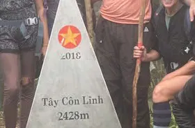
Chieu Lau Thi rises to 2,402 metres above Hoang Su Phi. Kieu Lieu Ti is a local and ethnic-language alternative name for the same mountain — not a separate peak. Tay Con Linh (2,428 m) is a neighbouring summit to the east. This page is mountain research: altitude, exposure, seasons, cloud inversions and how the crest sits above Hoang Su Phi terrace country.
For an overnight high-mountain trek, see the 2-day Chieu Lau Thi Cloud Sea programme. If you only have one day, see the Chieu Lau Thi Sunrise Ridge trek.
It is not a booking page and not a day-by-day itinerary. The two-day cloud-sea programme under Hoang Su Phi is the lodge-night walk; the one-day sunrise ridge under Ridge & Cloud is the same-day daylight climb. For schedule and fitness choice, read the one-day vs two-day programme comparison; for ridge conditions and light, read Chieu Lau Thi ridge: access, timing and summit light.
- Chieu Lau Thi — cloud sea (2 days)
Two-day lodge-night programme from Hoang Su Phi.
- Chieu Lau Thi — sunrise ridge (1 day)
One-day daylight programme under Ridge & Cloud.
- One-day vs two-day Chieu Lau Thi
Schedule, overnight and fitness — which programme to book.
- Chieu Lau Thi ridge: access, timing and summit light
Ridge conditions, pre-dawn logistics and descent — not calendar choice.
- The complete guide to trekking Ha Giang
Place the mountain within the wider province.
- Plan Your Ha Giang Trek
Compare its Demanding rating with other routes.
Exposure, cloud and the crest.
The summit experience is shaped by exposure rather than technical climbing. The eastern crest looks over karst valleys and terrace country; wind, cold and visibility change faster above 2,000 m than the forecast in Hoang Su Phi town suggests.
Cloud sea forms when valley inversions align — warm air trapped below, cooler ridge air above. It is never promised. Clear valleys still give ridge light, alpenglow and westward views across the massif.
Guides use marked standing lines on the eastern side when cloud fills the valleys, rather than waiting on the most exposed summit knob where wind and visibility can collapse quickly.
- Understanding the Chieu Lau Thi cloud sea
How valley inversions form at 2,402 m.
- Best time to trek Ha Giang
Month-by-month conditions across the province.
Altitude and exposure.
The 2,402 m crest is the highest point on the Ta Su Choong approach used by our current Chieu Lau Thi programmes.
Temperatures fall roughly six degrees Celsius per thousand metres of ascent. A mild valley morning can become a two to five degree Celsius ridge wait with wind chill lower — layering matters on any programme that reaches the crest.
Ethnic communities on the western approach are mainly Dao and Nung. The mountain sits above Hoang Su Phi terrace country; it is not an extension of a terrace walk.
- Hoang Su Phi programmes
Compare routes, difficulty and seasons at this collection hub.
- Ridge & Cloud programmes
Compare routes, difficulty and seasons at this collection hub.
Cold clarity or warmer ridge days.
Chieu Lau Thi programmes operate from October through April. October and November often offer the clearest ridge evenings; December to February brings colder nights and strong visibility; March and April bring warmer afternoons and rhododendron on upper slopes.
There are no departures from June through September, when storm conditions make upper-ridge plans unsuitable. Mountain weather can change much faster than the forecast in town — guides assess wind and storm signs before any summit push.
Photography belongs to the weather window you receive. Keep batteries warm in an inner pocket and avoid moving onto exposed ground simply for a wider frame.
Cold-season clarity and spring conditions on the massif
| October – February | March – April | |
|---|---|---|
| Ridge conditions | Colder nights and often clearer visibility | Warmer afternoons with changing cloud |
| Landscape | Dry ridge light and frequent cloud-sea potential | Rhododendron on upper slopes and spring colour |
| Photography | Protect batteries from the cold and work with wind | Expect softer light and variable visibility |
Ridge conditions
October – February
Colder nights and often clearer visibility
March – April
Warmer afternoons with changing cloud
Landscape
October – February
Dry ridge light and frequent cloud-sea potential
March – April
Rhododendron on upper slopes and spring colour
Photography
October – February
Protect batteries from the cold and work with wind
March – April
Expect softer light and variable visibility
- Packing for Ha Giang
Cold-weather trekking kit.
Chieu Lau Thi and neighbours.
Several routes touch this high-mountain country — each with a different intent. Chieu Lau Thi (also called Kieu Lieu Ti locally) is the 2,402 m summit our bookable programmes reach. The cloud-sea programme is the two-day lodge product from Hoang Su Phi. The sunrise ridge is the one-day daylight climb under Ridge & Cloud. Tay Con Linh (2,428 m) is a separate mountain — its cloud-forest route approaches from Cao Bo with a southern village finish. The Kieu Lieu Ti three-day traverse is a longer itinerary that used the local name in its title; it crossed the upper ridge with two shelter nights and is currently unavailable.
The Tay Con Linh Summit extended journey on our tours page is a separate three-day packaged product line on Tay Con Linh — not a substitute for the one- or two-day Chieu Lau Thi programmes above.
Choose by intent: book a programme for day rhythm and enquiry; use this guide for mountain context; use the compare articles for schedule or access decisions.
- Chieu Lau Thi — cloud sea (2 days)
Two-day Hoang Su Phi lodge product.
- Chieu Lau Thi — sunrise ridge (1 day)
One-day Ridge & Cloud daylight climb.
- Tay Con Linh cloud forest (2 days)
Southern Cao Bo approach with village finish.
- Kieu Lieu Ti three-day traverse
Full upper-spine crossing with two shelter nights.
Trekking operations on this route are currently unavailable, and we are not accepting bookings for it at present.
- Tay Con Linh Summit (extended journey)
Separate three-day packaged journey — secondary to 1–2 day programmes.
Trekking operations on this route are currently unavailable, and we are not accepting bookings for it at present.
Let the mountain set the pace.
Stay behind the guide on narrow, wet or exposed sections, and use marked standing areas at the summit. A safe line matters more than reaching the highest or windiest point for a photograph.
Weather decisions belong with the guide. Turning back, waiting for wind to ease or changing summit timing protects the group; cloud sea is never a reason to take unnecessary risk.
Guides from Dao and Nung communities read fog, wind and storm signs on the ridge. We cancel or postpone when lightning risk is real on either Chieu Lau Thi programme.
- Summit approach and mountain safety
Exposure, weather calls and evacuation context.
Common questions.
How difficult is Chieu Lau Thi as a mountain?
The massif is rated Demanding on our programmes — sustained uphill walking, cold ridge exposure and uneven ground above 2,000 m. Fitness requirements differ by product; compare programmes rather than treating this guide as an itinerary.
Is cloud sea guaranteed at Chieu Lau Thi?
No. Cloud sea depends on valley inversions and wind. When valleys stay clear, the summit ridge can still offer alpenglow and wide views across terrace country.
Which programme should I book?
Book the two-day cloud-sea programme if you want a lodge night at Chieu Lau Thi 2402m Lodge and a short pre-dawn walk from the lodge. Book the one-day sunrise ridge if your dates allow only a single calendar day with a morning town departure. Read the compare articles for detail.
How does Chieu Lau Thi relate to Tay Con Linh?
Chieu Lau Thi is the highest crest on the western Ta Su Choong approach. Tay Con Linh cloud forest uses a southern Cao Bo approach and descends to Thuong Son — same wider massif, different access and finish.
When can trekkers walk Chieu Lau Thi?
Programmes run October through April. June through September is storm season on Tay Con Linh — no departures on the commercial programmes.
Book a programme, not this page.
Use this guide for mountain context. When you are ready to book, open the cloud-sea or sunrise ridge programme page for highlights, day rhythm, price and enquiry — or read the compare articles if you are still choosing between products.
Send your dates and walking experience when you enquire. We help match programme to fitness and season.
- View Chieu Lau Thi cloud sea
Two-day lodge-night programme.
- View Chieu Lau Thi sunrise ridge
One-day daylight programme.
- One-day vs two-day Chieu Lau Thi
Schedule and fitness choice.
- Chieu Lau Thi ridge: access, timing and summit light
Ridge conditions and pre-dawn logistics.
- Enquire about a departure
Share your dates and walking experience with the team.
Published by Ha Giang Trekking — field knowledge from local trail guides on the routes described, checked against programme schedules and operating notes.
Journal pages are for route research and planning. Dates, prices, day-by-day schedules and enquiry sit on programme and tour pages.
Articles are published under Ha Giang Trekking. Named writer and guide bylines will be added when verified bios and consent are on file.
Operational details on programme and tour pages are published only after being checked against current operating information.
Compare published routes and open the programme or journey page when you are ready to enquire.
- Ridge & Cloud — compare summit programmes
Compare difficulty, seasons and walking style before you enquire.
- Chieu Lau Thi — cloud sea (2 days)
Chieu Lau Thi — cloud sea (2 days) — dates, pricing and enquiry.
- Chieu Lau Thi — sunrise ridge (1 day)
Chieu Lau Thi — sunrise ridge (1 day) — dates, pricing and enquiry.
- Kieu Lieu Ti three-day traverse
Trekking operations on this route are currently unavailable, and we are not accepting bookings for it at present.
Trekking operations on this route are currently unavailable, and we are not accepting bookings for it at present.
- Kieu Lieu Ti — booking, kit and preparation
Day-by-day walking detail and pacing for Chieu Lau Thi.
- Kieu Lieu Ti: A Guide to One of Ha Giang's Quietest Ridge Treks
Day-by-day walking detail and pacing for Chieu Lau Thi.
- Hoang Su Phi Rice Terraces: A Complete Guide for Trekkers
Landscape, seasons and routes around Hoang Su Phi.
- Tay Con Linh: A Complete Guide for Trekkers
Neighbouring walking country linked to Chieu Lau Thi.